
Temperatures in the UK look set to plunge later this month, falling below 0C in multiple areas, weather maps suggest. Forecast data collected by WXCHARTS.COM shows the mercury dropping to the single digits across the British Isles on Wednesday, October 27.
Maps showing minimum temperatures at midnight UTC (1am BST) suggest major cities in the southern half England will see temperatures dropping only to between 4 and 9C. In Wales, temps look set to drop as low as 3C, with the lowest as high as 9C on part of the northwestern coast.
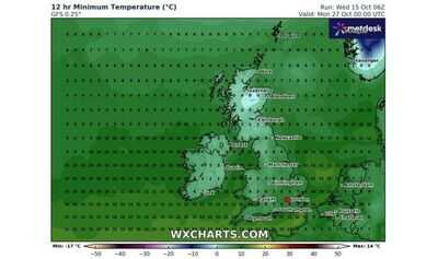
But up into northern England temperatures could drop to 2C in areas including parts of Lancashire. Scotland is set to see the most of the coldest temperatures around this time. Maps from earlier suggested temps could fall to -2C.
The latest maps show -1C temperatures concentrated in the top half of the nation.
Various counties in Scotland could be set for between 0C and -1C between 1am and 1pm, the maps suggest including: the Highlands, Moray, Perth and Kinross, Sterling, Argyll and Bute, western Angus, Aberdeenshire, Dumfries and Galloway, South Lanarkshire, the Scottish Borders, West Lothian, City of Edinburgh, Midlothian, and East Lothian, and down towards northern parts of Cumbria and Northumberland in the far north of England.
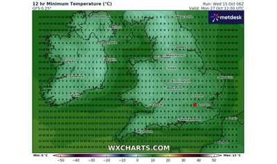
Meanwhile the lowest temperatures in Northern Ireland look set to range between 2 and 5C during this period.
The Met Office's long range forecast, which covers Monday October 20 to Wednesday, October 29 anticipates that a "rather unsettled pattern is likely through much of this period, as low pressure systems originating over the North Atlantic trundle east or northeastwards across the UK".
"These will bring showers or longer spells of rain, perhaps accompanied by some strong winds at times, but also interspersed with some drier and brighter interludes, albeit these generally of shorter duration than the recent settled spell," it adds.
"Later in the period, there may be a transition to a slightly cooler and more showery northwesterly regime, as high pressure builds over the Atlantic to the west, and low pressure becomes centred to the east of the UK.
"Temperatures are likely to be near or slightly above average overall, although may trend slightly below normal later."
Meanwhile, this evening and tonight it's expected to remaining cloudy for many in the UK.
"Mostly dry, but there will be some patchy light rain or drizzle possible across the south and east at times," the government agency adds. "Some clear spells developing, allowing it to turn rather chilly in places."
Thursday is expected to be cloudy "with some outbreaks of drizzle here and there, more especially across the south and east".
"An increasing chance of showers across northeast Scotland. Some brighter spells developing in places."
You may also like

Keir Starmer publishes China spy scandal witness statements in huge bombshell
JLo reveals if she has ever been 'truly loved'
'Proud Dad of US Marine' deported by ICE agents moments after visiting pregnant daughter at California military base
Duke of Kent's rare appearance at somber event alongside Queen Camilla's ex-husband
Man Utd slammed over two 'weird' decisions as Red Devils players blamed


